
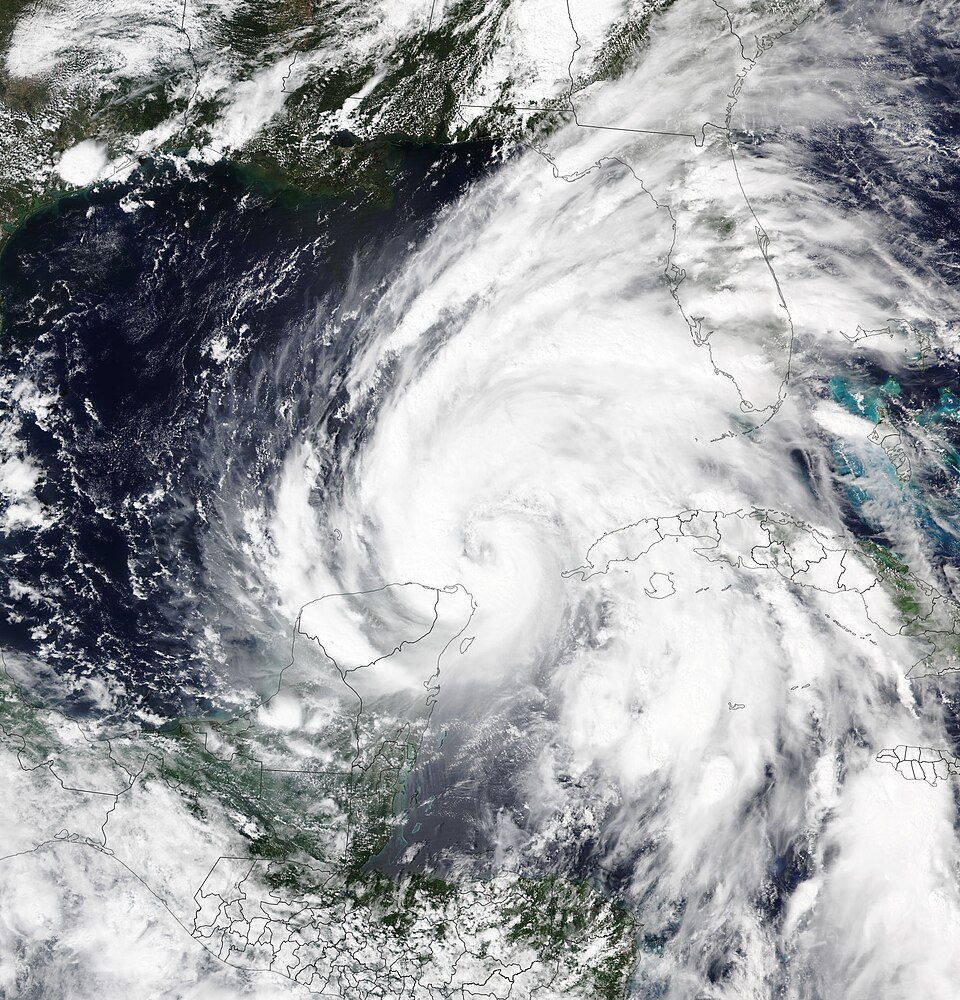
Tropical Storm Bertha Makes Two Gulf Coast Landfalls With Limited Flooding Risk
Tropical Storm Bertha made two Gulf Coast landfalls — first in St. Bernard Parish, Louisiana, and then near the Texas-Louisiana line — and forecasters said inland flooding risk is limited.[1]
The National Hurricane Center said Bertha hit St. Bernard Parish Wednesday with about 45 mph sustained winds.[2] Forecasters reported tropical-storm-force winds extending about 160 miles from the center and a 44 mph gust at New Orleans Lakefront Airport.[2] After the second landfall on Thursday near the Texas-Louisiana state line, the National Hurricane Center said the storm should weaken rapidly over land.[1] As of Thursday, officials reported no deaths or significant damage.[1]
Bertha formed Monday in the Gulf of Mexico south of Florida and was the second named storm of the 2026 Atlantic season.[1] Early forecasts warned of heavier impacts, with CBS saying communities were bracing for up to 4 feet of storm surge and multiple feet of rainfall as the storm closed in.[3] National Hurricane Center deputy director Jamie Rhome said strong northeasterly wind shear pushed most of the storm's weather offshore and added, "we're not expecting a big flood event." NPR
Early coverage emphasized worst-case surge and heavy-rain scenarios, notably CBS's forecasts of multiple feet of storm surge.[3] Later reporting by NPR and PBS shifted the tone, noting that the heaviest rains remained offshore and that inland flooding threats were reduced.[2]
Show source details & analysis (6 sources)
📌 Key Facts
- The National Hurricane Center said Tropical Storm Bertha made landfall Wednesday, July 22, 2026, in St. Bernard Parish, about 40 miles east of New Orleans, with maximum sustained winds around 45 mph.
- On Tuesday, July 21, 2026, CBS News reported forecasts calling for up to 4 feet of storm surge and said New Orleans-area communities were bracing for multiple feet of rainfall as Bertha closed in.
- Jamie Rhome, the National Hurricane Center deputy director, said strong northeasterly wind shear was pushing most of the storm's weather offshore and keeping Bertha from strengthening, adding “we're not expecting a big flood event” after the storm came ashore early Wednesday, July 22, 2026, with reported winds up to 60 mph and storm surge near 3 feet.
- Forecasters said the heaviest rains remained offshore at landfall, reducing inland flooding risk, with forecast rain totals of 1 to 4 inches and locally higher amounts.
- PBS News reported that Bertha made a second landfall Thursday afternoon, July 23, 2026, near the Texas–Louisiana state line about 75 miles northeast of Galveston, and the National Hurricane Center said the storm should weaken rapidly over land.
- Forecasters reported tropical-storm-force winds extending as far as 160 miles from the center and a 44 mph gust at New Orleans Lakefront Airport; Louisiana Gov. Jeff Landry called the forecast encouraging but urged residents to prepare as storm surges up to 3 feet were possible in parts of Louisiana and Alabama.
- As of Thursday, July 23, 2026, PBS News said no deaths or significant damage had been reported since Bertha formed Monday in the Gulf south of Florida, and noted it was the second named storm of the 2026 Atlantic season.
📰 Source Timeline (6)
Follow how coverage of this story developed over time
- On Thursday afternoon, July 23, 2026, Tropical Storm Bertha made a second landfall near the Texas-Louisiana state line, about 75 miles (115 km) northeast of Galveston, Texas.
- The National Hurricane Center said Bertha should weaken rapidly over land following this second landfall.
- Forecasters reported that only some coastal storm surge and isolated flash flooding were possible as the system moved inland.
- As of July 23, 2026, no deaths or significant damage had been reported from Bertha since it formed Monday in the Gulf of Mexico south of Florida.
- The article reiterates that Bertha first made landfall on Wednesday, July 22, 2026, as it grazed the Louisiana coast southwest of New Orleans and notes it is the second named storm of the 2026 Atlantic hurricane season.
- The National Hurricane Center said Tropical Storm Bertha made landfall Wednesday afternoon, July 22, 2026, in St. Bernard Parish, about 40 miles east of New Orleans, with maximum sustained winds around 45 mph.
- Forecasters reported tropical-storm-force winds extending as far as 160 miles from the storm center, with a 44 mph gust recorded at New Orleans Lakefront Airport on Wednesday afternoon.
- The heaviest rains remained offshore at landfall, and the National Hurricane Center said this reduced inland flooding risks, with forecast rain totals of 1 to 4 inches and locally higher amounts.
- Louisiana Gov. Jeff Landry called the forecast encouraging but urged residents to prepare for some flooding, as storm surges up to 3 feet were possible in parts of Louisiana and Alabama.
- Louisiana was simultaneously under tropical storm and extreme heat warnings for much of Wednesday, which the National Weather Service said was the first such combination in at least two decades for the area, based on records back to 2005.
- Bertha is expected to maintain tropical-storm intensity as it moves toward the Texas coast on Thursday, according to the National Hurricane Center.
- CBS reports that Tropical Storm Bertha made landfall in Louisiana on the afternoon of Wednesday, July 22, 2026.
- CBS segment centers on updated projections of Bertha's track across the region, as described by CBS News meteorologist Jessica Burch.
- Tropical Storm Bertha came ashore in southeastern Louisiana early Wednesday, July 22, 2026, with winds up to 60 mph and storm surge up to about 3 feet.
- National Hurricane Center deputy director Jamie Rhome said strong northeasterly wind shear is pushing most of the storm's weather offshore and is expected to prevent Bertha from strengthening.
- Rhome said "we're not expecting a big flood event" and that, if the forecast holds, Louisiana could avoid the worst potential impacts from the storm.
- A tropical storm watch remained in effect for New Orleans and Louisiana's southern Gulf Coast as of Tuesday afternoon, July 21, with coastal flood warnings for parts of Louisiana and Mississippi.
- The National Weather Service said isolated flash flooding remains possible from western Florida through the upper Texas coast.
- The article reiterates official seasonal outlooks that call for slightly fewer Atlantic storms in 2026 but stresses unusually warm Gulf and Atlantic waters that can fuel stronger systems.
- On Tuesday, July 21, 2026, CBS reported Tropical Storm Bertha was closing in on the Gulf Coast, with forecasts calling for up to 4 feet of storm surge.
- The CBS segment said New Orleans and surrounding areas were bracing for multiple feet of rainfall from Bertha's approach.
- The report emphasized imminent landfall conditions compared with earlier, more general forecasts of 2 to 4 inches of rain and up to 4 feet of surge.